
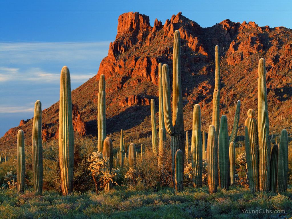
The most painted and photographed landmark in Arizona, after the Grand Canyon, is Superstition Mountain, rising 3000 feet above the desert floor of the Salt River Valley in the Tonto National Forest - the whole lying inside the boundaries of the huge Sonoran Desert. It encompasses 242 square miles of rocky cliffs.The climate is treacherous. Summer temperatures soar over 125 degrees with little or no water in sight. In the cooler season, snow can cover the peaks and even the desert base can plunge below freezing. Wood to use for fires is scarce, the forest plants here are cacti. Food is questionable, assuming you could catch anything. And, the wildlife is hungry too - you might look pretty good to them.
Why would anyone care? GOLD. The romance and allure of finding the Lost Dutchman Mine is just irresistable. Jacob Waltz left no clues and has been dead for over a 100 years, yet maps and forays into the Superstitions have continued for all that time. Interested?
Well, you're going to need a map. It just so happens that there are dozens of those. There are 62 documented maps on record, even though Mr. Waltz wasn't talking. How tough can this be? Lets take a look.

From an unspecified point which may be along a river, a road or just the bottom of the page, we travel toward some benchmark. Did someone draw an "X" on the ground there? We know it is after the "deep cliffs", but that's sort of a relative term isn't it; everything is a deep cliff. Now, "facing W of SW third of 4 peaks over right shoulder". Hmmm. Somewhere, with 3 red hills in front of me as I am facing WSW, I'm to look over my right shoulder. I will be looking at the 3'rd of 4 peaks.....behind me? What does that accomplish? Maybe there is a hill shaped like an arrow pointing the way. Obviously, either the map is not to scale, or the kidney shaped pit is both miles and miles away from "X" and half the size of Lake Michigan. This just won't do. Better try again.

This is a little better. Places have names, but I doubt there are street signs. If we find a place called Buzzards Roost while facing Coffee Mountain there will be a trail heading....up? Did no one own a compass? Going up, we find "Reid's Water", further along the road forks and if we bear left we will come to "Reid's Silver Queen Mine". Off to the right of Buzzards Roost are "old markers", but we would just have to know what they looked like, it isn't specified. Then, before the trail turns "up" again, a strange little symbol is off to the right and looks like a shovel. Dig here? Now we sort of know where we are, but have no idea what to do with it. Lets get another map.

This one has Spanish references, so those will have to be identified. Other than that, try this one out on a topo map and see where you end up. It is not easy to find a starting point without some sort of scale. Well, there are dozens of these maps. Lets just get another.

Much, much better. Trouble is, the "Phoenix Don's Club" has had this information for years and haven't had much luck. I love the detailed description of the sun shining through the two notches of "Horse's Head" in the hills to land on "X" halfway up a mesa some unspecified distance away. Not sure which mesa, there are lots of them. Well, that's just crystal clear.
I'm way ahead of anybody looking for gold. The Superstitions are just beyond Apache Junction, an easy drive from here. I'll pack a picnic and take a moment to be in the desert air with those mountains as a backdrop and that luminous blue sky overhead. Just LOOK at the picture.
If that isn't golden, nothing is.
(Blogger has improved it's posting pages. Consequently, this post, which was written before that, has a few quirkly colors and fonts. Your PC is fine, it's me, I'll get it right next time.)


.jpg)


Linda I am no good with maps, so I guess we will have to stay and visit on blogland lane.
ReplyDeleteLinda, I want to thank you so much for the beautiful story that you wrote.
You write beautifully and care deeply and I want you to know that I appreciate and loved what you wrote.
Love Renee xoxo
Gorgeous! I really need a trip out west soon to reconnect with the mountains.
ReplyDeleteRenee, its such a small thing in the face of all you bear. I wish you beauty and peace in every step you take. And, I plan to read to you!
ReplyDeleteDebra Kay,
Girl, you ain't seen nuthin' yet! Stay in touch and I'll show you places you won't believe.
Thars gold in them thar hills!
ReplyDeleteWhich map are you going to try first?
Don't forget a mule and some water ;-)
Cool Post!
Brad
We ought to take a picnic and the kids up there to see what they can find!
ReplyDeleteMom
Linda you tell such a good story, I feel almost like I was there.
ReplyDeletexoxo